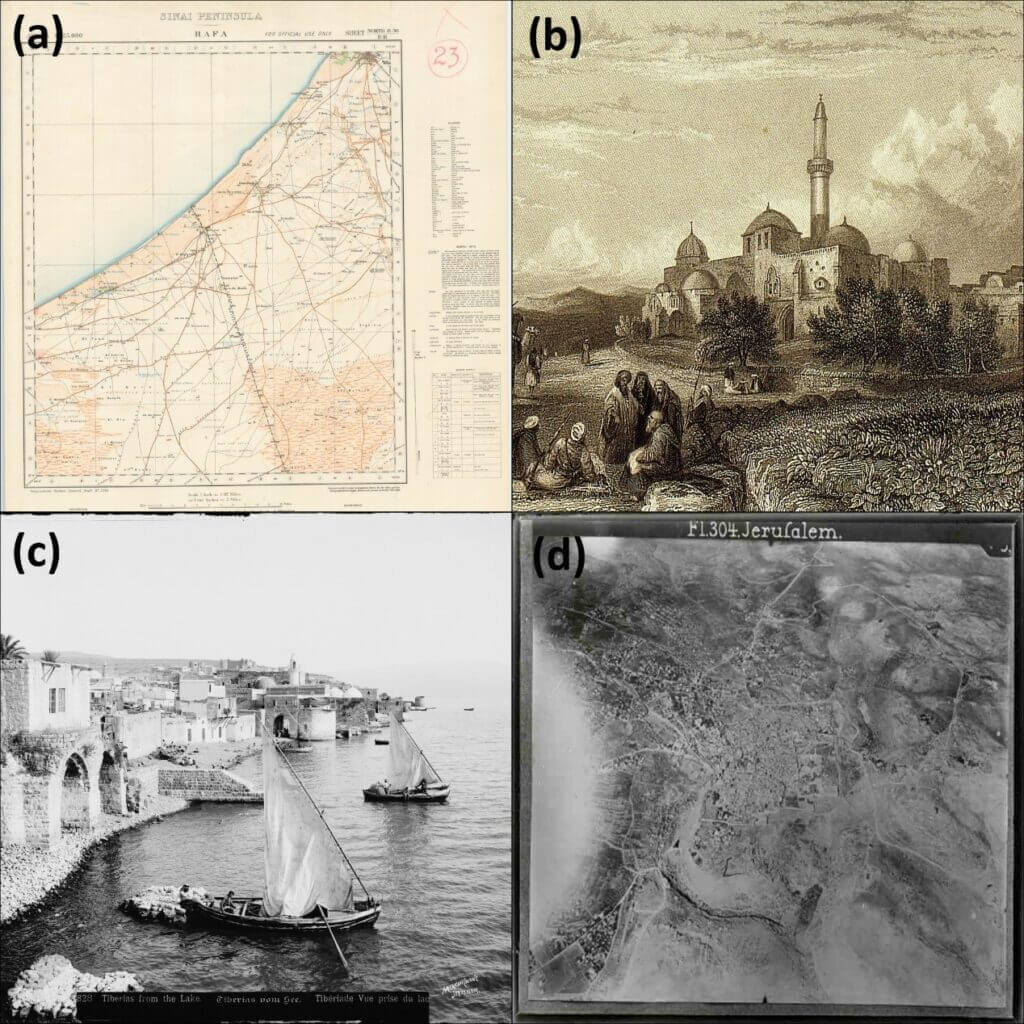
Researchers analyzed historical visual sources, such as maps, paintings and aerial photographs of Jerusalem and Haifa, to examine their urban development
How did the major cities in the Land of Israel develop from the middle of the 19th century to the beginning of the 20th century, the end of the Ottoman rule and the beginning of the British Mandate rule? "Until the end of the 18th century, the Land of Israel and its cities such as Acre, Haifa, Jerusalem, Jaffa, Safed and Tiberias did not capture European and global attention. Napoleon's campaign and other geopolitical changes (such as the weakening of the Ottoman Empire) led to urban and demographic changes and the strengthening of the cities compared to the villages and an increase in interest in them," says Dr. Moti Zohar from the Department of Geography and Environmental Studies at the University of Haifa.
What is the question? What are the urban changes that took place in the major cities in the Land of Israel at the end of the Ottoman period and the beginning of the British Mandate, and what can be learned from them?
In their latest study, Dr. Zohar and his partner, Prof. Ilan Shimshoni from the Department of Information Systems at the University of Haifa, asked to examine the urban development of Haifa and Jerusalem, and the urban changes that took place in them from the middle of the 19th century to the beginning of the 20th century. Dr. Zohar says: "We are talking about 70 years in which there were significant changes in the urban landscape of the Land of Israel - the five waves of immigration to the Land, the establishment of Zionism in the area (in demography and landscape), and in fact also the beginning of the Israeli-Arab conflict - so we focused on this period. In addition, Haifa and Jerusalem were chosen due to their centrality starting in the mid-19th century."
The researchers used historical visual sources - such as maps, paintings and aerial photographs - of Jerusalem and Haifa (for example of Mount Carmel, the Mount of Olives and the Old City in both cities), which are kept in collections and archives (in universities and the state treasury). "From the middle of the 19th century to the beginning of the 20th century, these visual sources began to expand also due to the fact that the political and political attention of the European powers was directed to the Middle East - delegations from the British, the Germans and the Russians arrived in Israel, including researchers and academics," explains Dr. Glamor.
Until now, researchers have analyzed such visual sources with the naked eye. Dr. Zohar and his partner analyzed them with tools from the field of geoinformatics, MMG software and machine learning algorithms. This is how they scanned the sources and received digital files from which entities such as buildings, roads, public buildings, telegraph lines, water sources and infrastructures could be extracted (and decoded). We anchored these entities to the space - that is, connected them to points of interest that still appear in the area today. This is how they discovered urban changes that took place in practice and made measurements of distances, directions and areas. In the next step, the algorithms were taught to analyze the visual sources and identify entities in them ("for example, a black bar represents a public building and a blue bar represents a road"). After that, they ran the algorithms on the tested sources, and they analyzed them and extracted spatial entities from them, such as the walls of the old city, King David's tomb, monasteries and mosques. Then the researchers verified the extracted entities (to make sure, for example, that a building was not identified as a cistern) and examined the changes of the entities over the years, in time and space (a research phase that is still ongoing).
The researchers were able to draw conclusions about the urban and human environment in Jerusalem and Haifa. "When, for example, we know the exact number of buildings in a certain area and estimate that four to 12 people can live in them, we can deduce the size of the population and characterize the space. In 1860, for example, the exit from the walls of the Old City in Jerusalem began and more buildings and structures were added outside them, and through the research it is possible to understand in which areas the greatest urban development took place."
The researchers were able to draw conclusions about the urban and human environment in Jerusalem and Haifa. When, for example, we know the exact number of buildings in a certain area and estimate that four to 12 people can live in them, we can deduce the size of the population and characterize the space.
This is how the researchers concluded the number of residents who lived in Ottoman Israel before the first wave of immigration - about 350,000 (of which they estimated how many residents lived in Jerusalem and Haifa), similar to the conclusions of previous studies that were made with qualitative tools only. "From this we learn that the land was not empty before the first wave of immigration. From then until the present day, a struggle between two narratives takes place - according to the Zionist narrative, the land was empty of people until the arrival of the first Aliyah, and the Arab narrative claims that the opposite is true. We do not pretend to decide this and similar issues, but produce data using technology and place them at the doorstep of historians. In fact, we provide them with additional tools for studying history."
Life itself:
Dr. Moti Zohar, 52 years old, married + three (19, 16, 8), lives in Kfar Oranim. Likes to travel, read and swim. Strongly supports making science accessible to the general public ("It is very important that research leads to the general public as well").
