US Geological Survey warns of major risks to infrastructure due to rapid land subsidence in many coastal cities

New research from Virginia Tech University and the United States Geological Survey reveals major gateways along the Atlantic coast of the United States are sinking at rates exceeding global sea level rise, with areas such as New York, Long Island, Baltimore, Virginia Beach and Norfolk experiencing subsidence significant land. This phenomenon poses risks to critical infrastructures.
Cities along the Atlantic coast of the United States are sinking up to 5 mm per year. (It's a rate) faster than global sea level rise, which poses risks to infrastructure in densely populated areas like New York and Baltimore. Studies by Virginia Tech and the United States Geological Survey emphasize the urgency of addressing this issue.
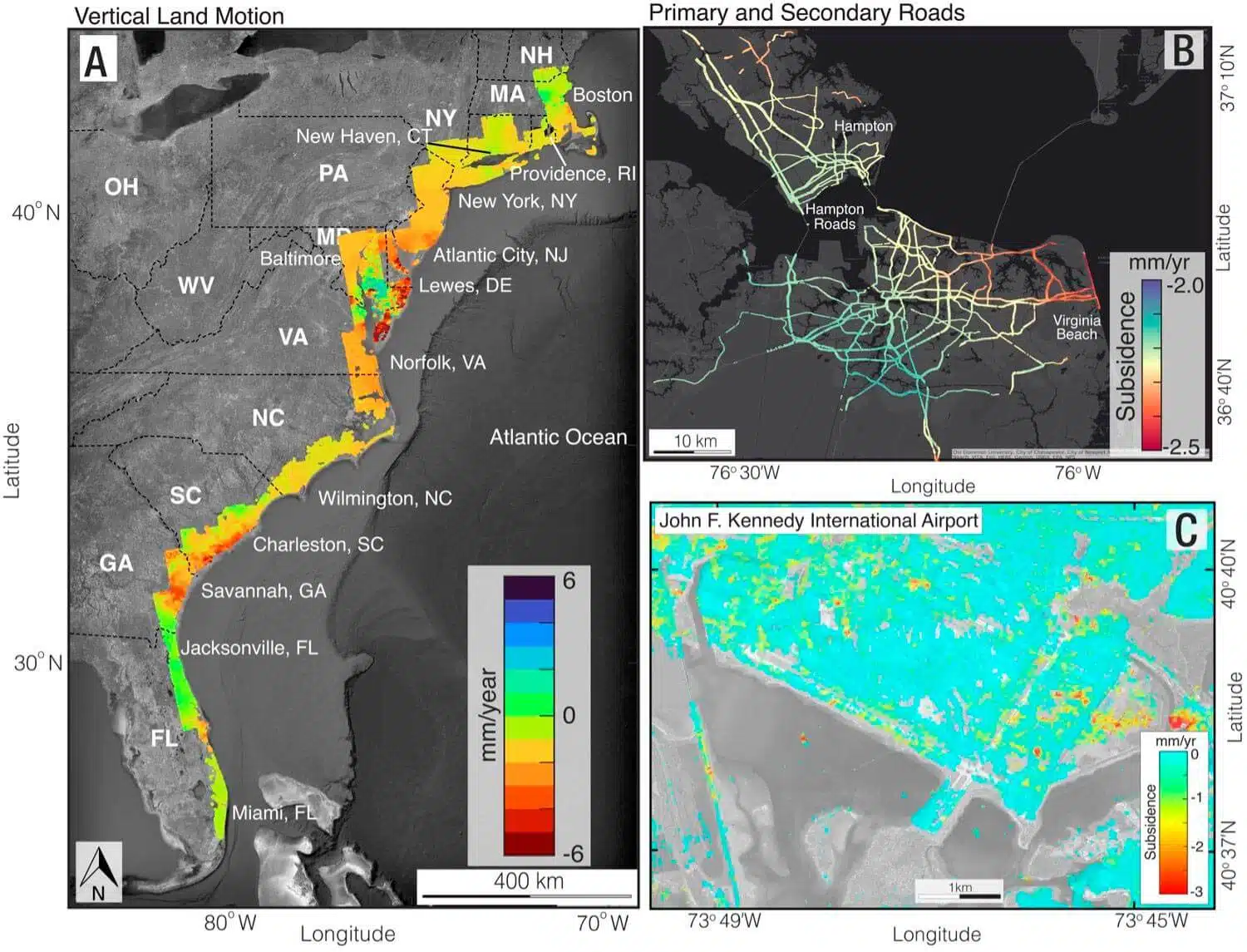
Population centers especially prone to danger such as New York and Long Island, Baltimore, Virginia Beach and Norfolk experience areas of rapid subsidence, or land subsidence, alongside land that sinks relatively slowly or steadily, which increases the risk of damage to roads, flight paths, building foundations, railroads, and pipelines, according to a study published on January 2 in the journal Proceedings of the National Academies of Sciences.
Researchers from Virginia Tech University, and from the United States Geological Survey, used satellite data and created accurate digital maps showing where land subsidence poses a risk to vital infrastructure. These innovative maps show that a large area along the East Coast is sinking at least 2 mm per year, with areas along the Mid-Atlantic coast sinking more than 5 mm per year.
The study shows that in several cities along the East Coast, multiple critical infrastructures such as roads, railroads, airports and batteries are affected by different rates of subsidence. According to the researchers, the problem is not only that the land is sinking, but that the centers of subsidence coincide directly with centers of population and infrastructure.
The study measured how much the land along the eastern coast has sunk, while populations and critical infrastructure up to 100 km from the coast are at risk of land subsidence. Land subsidence can undermine building foundations, damage roads, gas and water pipelines, cause buildings to collapse, and worsen coastal flooding - especially in combination with sea level rise caused by climate change.
"This information is necessary. No one else provides it," said Patrick Barnard, a research geologist from the United States Geological Survey and co-author of the study. "Shirzai and his team at Virginia Tech have filled this niche with their technical expertise and are delivering something extremely valuable."
The study presents vital information about the risks to critical infrastructure in major cities along the East Coast of the United States due to accelerated land subsidence. It is hoped that the information will lead to governmental and other actions to prevent damage to these infrastructures and protect the populations living in these areas from floods and natural disasters.
A few more points:
- The study emphasizes that land subsidence occurs at a faster rate than global sea level rise. This is a significant problem as it significantly increases the risk of flooding in these areas.
- The satellite data used in the study provide very accurate measurements of the land subsidence. Using such advanced technologies is essential to better understand the risks.
- Further research is needed to understand the causes of land subsidence in each area - whether it is a rise in groundwater, compaction of soft soils or other factors.
- It is important that the information be used to plan future infrastructure in these areas - for example by building higher above sea level or strengthening existing buildings and infrastructure.
- It may be necessary to move critical infrastructure to areas less prone to subsidence in the long term.
- Local and federal governments should act urgently to deal with the risk, among other things by investing in infrastructure and coastal protection.

2 תגובות
The geological survey?
come on.
USGS – US Geological survey
A proper translation would be the Geological Institute
Is that why Kerry and Obama are buying real estate on the beach? liars