The research from the Hebrew University determines for the first time, through archaeological and historical means, the boundaries of the kingdom of King David and his grandson, King Rehoboam and resolves the long-standing debate about the very existence of the kingdoms and their urban boundaries
A new study by Prof. Yossi Garfinkel from the Institute of Archeology at the Hebrew University, which was published in the prestigious Jerusalem Journal of Archeology, determines for the first time what the boundaries of the urbanization process and the planning of the early phase of the Kingdom of Judah were during the time of King David and where the central administration of King David's Kingdom was located at the beginning of the tenth century BCE XNUMX and of King Rehoboam, at the end of the tenth century BC.
From around 1980, heated disagreements arose about the historical value of the biblical traditions dealing with the tenth century BC, the time of Kings David, Solomon and Rehoboam. Some researchers claimed that urbanization in Judah only began at the end of the ninth century BC, about 200 years after David, and even at the end of the eighth century BC, about 300 years after David. A vulgar view even claimed that in the days of David there were 500 people who walked with sticks, shouted, cursed and spat. The new study is important for the historical study of the First Temple period, and for the study of the biblical tradition about King David and it proves beyond all doubt the existence of the kingdom.
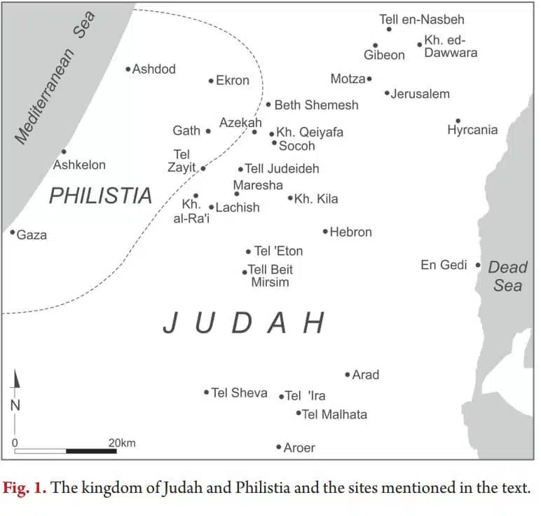
The way in which David's kingdom was defined is through a group of cities in the form of "enclosing walls" (a wall with two parallel walls, divided into rooms), which are established only on the perimeter of the kingdom and protect a main road to the heart of the kingdom. Fortified walls have been found over the years at a number of sites and now, as Prof. Garfunkel found in his article, these walls date back to the beginning of the tenth century BC, the days of King David's reign, and they teach us where the Kingdom of Judah extended during his reign.
The analysis in the article shows that during the time of David there was a kingdom in Judah, which controlled territories on the back of the mountain and in the north of the Judean lowlands. Cities in the form of enclosing walls marked the borders of the kingdom, and protected the axes of the main roads that led towards Jerusalem. The location of the closing walls, on roads known to us as main roads at a distance of up to a day's walk from Jerusalem, which was the heart of the kingdom of Judah, and the fact that the walls were built in a similar style suitable for the period, teaches us that these are the borders of the ancient kingdom.
According to the new study, the borders of the kingdom were at the ruins of Kyapa, which sits on the Elah Valley road, at the western end. Beit Shemesh, sits on Nahal Sorek Road, at the western end. Tel Netzva, on the main road on the side of the mountain, which sits on the northern edge and the ruins of Duara, which sits on the northeastern edge. The location of the walls and the way they were built teaches us that in the days of King David it is possible to find a strong central government, with a clear concept and urban plan that delineates the central borders of his kingdom with thought and intention first.
Also, the research found that during the time of King Rehoboam, at the end of the tenth century BC, the Kingdom of Judah grew and it included additional urban centers, some on the back of the mountain, and some in the north and central lowlands. Then Lachish was also built, the second most important city in the Kingdom of Judah. This corresponds with the series of Rehoboam's fortifications, as stated in the book of 15 Chronicles, chapter XNUMX, according to which Rehoboam fortified XNUMX cities.
Prof. Garfinkel explained the findings of the research and said that "finding a barrier wall in this area de facto marks the boundaries of the urban core of the Kingdom of David and ends the historical debate that has been going on for decades about the very existence of the Kingdom of David and its borders." Prof. Garfinkel continued and explained that "this shows that the biblical documentation regarding the expansion and strengthening of King Rehoboam is indeed true and we are indeed offered evidence on the ground, dated to this time, of the urban expansion mentioned in the Book of Chronicles." These are one of the only times in which it was possible to give empirical historical and archaeological evidence regarding what is said in the Bible book about the tenth century B.C. Prof. Garfinkel explained the date of publication of the study and said that "the evidence was always there, it is not about new findings, someone was needed to come and see the overall picture that they tell. Glad I was able to do that."
The excavations on which the conclusions were based were carried out in collaboration with Sa'ar Ganor from the Antiquities Authority and Prof. Michael Hazel from the Southern Adventist University.
For the full article: Link
More of the topic in Hayadan:

5 תגובות
.. and it's also time to use the feminine language as well, at least regarding responses..
I refrained from entering into the long debate between the distinguished professors. But it is certain that this article is written in such a poor way that I can only hope that it does not indicate the research itself. And it's a shame because I expected to laugh. A clear map would help on the one hand, and marking boundaries after proofreading on the other hand
Come on. Another irresponsible and excessive attempt to prove a kind of political, geographical infrastructure for the expansion of the Kingdom of Judah. Fortified cities were indeed settled for them, but from what? There is no certainty that this is the controlled extent of any kingdom, because between those cities some kind of tactical and strategic border had to be stretched in order to talk about any kingdom, including the control of patrols and any fire signals, unlike the rare case of the biblical city of Azka in the days of Hezekiah and more of this kind . And for the purpose of comparison in this regard, one should point to the vast Roman Empire, for example, or the limits of Hellenic ethics, etc.
Well, that's another goal against Israel Finkelstein, the fake history professor. You caught a lot you didn't catch, said the Sages, and the "studies" blown up with their extreme conclusions and the arrogance of this gentleman turn out to be an ever-deflating balloon. In front of the multitude of studies and contradictory findings, the failure of this bluff already looks like Manita.
Perhaps the time has come for the Dan David Foundation to reconsider the award he received in 2005. Also his membership in the Israeli National Academy of Sciences, the American Academy of Nationalism and Sciences, as well as the multitude of honorary degrees he received from the French, the Swiss and even the Chinese - seem more and more far-fetched as the years go by.
A time traveler brought a newspaper from the year 5411 in which it is written on the front page: "For the first time, the reasons for the destruction of the third house during the reign of Emperor Bibiho I and a friend of his people and the scattering of the people of Israel into exile after the civil war that broke out were found. The two responsible for the collapse were two weak and spineless leaders: Herzogya and Gantzya and the delay of the defense minister, the collaborator, Galantya, the army and the secret services to start a counterattack. And so the legendary Israel became a name from the world of imagination like Atlantis and the unicorn. The remaining Jews wandered like the gypsies in the world for thousands of years and on the other hand the pilots of the country that was destroyed became in demand in all the armies of the whole world and the hi-techists also integrated well. The Arabs who occupied the country in 2026 used up all its resources and burned it until it became a wasteland and when the surviving ultra-Orthodox asked billions of Muslims for abrachs, kollels and yeshivas they managed to kill some of them with loud and uncontrollable laughter.